Understanding groundwater resources is crucial, and the water table serves as a vital indicator of their health. The United States Geological Survey (USGS) monitors the water table levels across the nation. Its depth impacts everything from agricultural irrigation to the construction of stable foundations. Furthermore, hydrogeology, the study of groundwater, directly concerns itself with understanding the dynamics of the water table and predicting its fluctuations.
The water table: It’s a phrase we often hear in discussions about water resources, environmental management, and even real estate.
But what exactly is the water table, and why should we care about it?
This invisible yet critical boundary beneath our feet represents the upper limit of the saturated zone, where the ground is completely filled with water.
Understanding its dynamics is not merely an academic exercise; it’s crucial for safeguarding our water supplies, protecting ecosystems, and making informed decisions about land use and development.
Defining the Water Table: A Critical Natural Resource
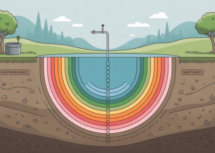
At its simplest, the water table is the surface of the groundwater. It represents the level to which water will naturally rise in a shallow well.
Below this level, the earth is saturated. Above it, the soil and rock may be damp, but they are not fully saturated.
The water table isn’t a static, uniform layer like the surface of a pond. It fluctuates depending on rainfall, snowmelt, and groundwater usage.
Its depth can vary significantly, from being very close to the surface in wetlands to hundreds of feet below ground in arid regions.
The water table is a vital natural resource because it serves as a primary source of fresh water for countless communities and ecosystems worldwide.
It sustains rivers, lakes, and wetlands, providing essential habitats for diverse plant and animal life.
Furthermore, it’s a critical reservoir that we tap into for drinking water, irrigation, and industrial processes.
Why Understanding the Water Table Matters
The importance of the water table extends far beyond the realm of scientific curiosity. Its understanding is crucial for a wide range of stakeholders:
-
Homeowners: The depth of the water table can impact the feasibility of building basements, the performance of septic systems, and the risk of flooding.
-
Farmers: Access to groundwater from the water table is essential for irrigation, ensuring crop production and food security.
-
Policymakers: Effective water management policies require a thorough understanding of the water table’s dynamics, including recharge rates, discharge points, and potential contamination sources.
-
Environmentalists: Protecting the water table from pollution and overuse is vital for preserving aquatic ecosystems and ensuring the long-term health of our planet.
-
Developers: Knowledge of water table levels is critical for planning construction projects, ensuring that they do not negatively impact the water supply or increase flood risks.
In essence, the water table is a shared resource that requires careful management and protection.
Mismanagement can lead to water shortages, ecosystem damage, and economic hardship.
Guide Overview: Navigating the Subsurface World
This exploration will guide you through the intricacies of the water table, providing a comprehensive understanding of its characteristics, dynamics, and challenges. We will delve into the following key areas:
-
The Definition and Location of the Water Table: We’ll explore the scientific definition of the water table and examine the factors that influence its depth and location.
-
The Water Table and Groundwater Dynamics: We’ll investigate the relationship between the water table and groundwater, including aquifers, recharge, and discharge processes.
-
Threats to the Water Table: We’ll identify the various threats to the water table, including contamination, land use changes, and climate change.
-
Monitoring and Management: We’ll discuss the importance of monitoring water levels and implementing sustainable practices to conserve groundwater resources.
The importance of understanding the water table cannot be overstated, serving as the foundation for informed water resource management and environmental protection. But to truly grasp its significance, we must move beyond a simple definition and explore the surrounding environment that shapes its existence.
Defining the Water Table: A Comprehensive Look
Differentiating the zones above and below it, understanding the factors that influence its position, and recognizing the role of the capillary fringe are all essential components of a comprehensive understanding. This deeper exploration provides a clearer, scientifically accurate perspective of this vital subsurface feature.
Saturated Zone vs. Unsaturated Zone (Vadose Zone)
The subsurface can be broadly divided into two distinct zones: the saturated zone and the unsaturated zone, also known as the vadose zone. The water table marks the boundary between these two fundamentally different regions.
Understanding the characteristics of each zone is crucial for comprehending groundwater dynamics.
Characteristics of the Saturated Zone
The saturated zone is the area beneath the water table where all the pores and spaces within the soil and rock are completely filled with water.
This is the realm of groundwater, a critical source of fresh water for human consumption and ecological sustenance.
Within the saturated zone, water movement is governed by hydraulic gradients and the permeability of the geologic materials.
Characteristics of the Unsaturated Zone (Vadose Zone)
Above the water table lies the unsaturated zone, where the pores contain both air and water.
This zone is characterized by capillary action and soil moisture.
Water in the unsaturated zone is held in place by surface tension and adhesive forces, making it less readily available than groundwater.
In other words, the vadose zone is not fully saturated.
Factors Influencing the Location and Depth of the Water Table
The water table isn’t a static, level surface; its location and depth fluctuate based on a complex interplay of factors.
Understanding these factors is crucial for predicting groundwater availability and potential environmental impacts.
Key Factors Determining Water Table Depth
Precipitation is a primary driver, with rainfall and snowmelt replenishing groundwater supplies and raising the water table.
Conversely, extended periods of drought can lead to a decline in the water table.
Groundwater extraction through wells and pumping can also significantly lower the water table, especially if withdrawal rates exceed recharge rates.
Surface water bodies, such as rivers and lakes, can act as either recharge or discharge zones, depending on their elevation relative to the water table.
Vegetation plays a role too, with plants drawing water from the soil through transpiration, potentially lowering the water table in vegetated areas.
The Impact of Local Geology
The geologic composition of an area has a profound impact on the water table’s position.
Permeable materials, like sand and gravel, allow water to flow easily, leading to a relatively shallow water table.
In contrast, impermeable layers, such as clay or bedrock, can restrict water movement, resulting in a deeper or perched water table.
Perched water tables occur when a localized impermeable layer traps water above the main water table, creating a localized zone of saturation.
The Capillary Fringe and Its Role
Above the water table, there exists a zone called the capillary fringe.
This is a transitional zone where water rises slightly above the water table due to capillary action.
Capillary Action Explained
Capillary action is the ability of water to move upwards against gravity in small spaces, such as the pores between soil particles.
This phenomenon is caused by the cohesive forces between water molecules and the adhesive forces between water and the surrounding soil particles.
Relevance to Plant Life and Soil Moisture
The capillary fringe plays a crucial role in supplying moisture to plant roots, particularly in areas where the water table is relatively deep.
It also contributes to soil moisture in the unsaturated zone.
The height of the capillary fringe depends on the soil type, with finer-grained soils exhibiting greater capillary rise than coarser-grained soils.
This zone essentially forms a bridge between the saturated zone and the root zone of many plants, making it an essential component of the overall water table system.
The Water Table and Groundwater Dynamics: An Interconnected System
Having explored the definition and surrounding environment of the water table, it’s essential to understand how it functions within the broader hydrological cycle. The water table isn’t an isolated entity; rather, it’s a dynamic component intimately linked to groundwater systems, recharge mechanisms, and discharge points. Delving into these interconnections reveals the true complexity and significance of this critical subsurface feature.
Groundwater: A Vital Resource
Groundwater, simply put, is water found beneath the Earth’s surface, residing in the saturated zone. It is a crucial resource, providing drinking water for a large portion of the global population and supporting agricultural irrigation across vast areas.
Without groundwater, food production in many regions would be severely limited.
Its importance is often underestimated because it is out of sight.
Groundwater is the lifeblood of many ecosystems.
Statistics underscore its significance. According to the United States Geological Survey (USGS), groundwater accounts for approximately 22% of all the fresh water used in the United States. Globally, it provides drinking water for an estimated 2 billion people. Furthermore, it supplies a significant portion of the water used for irrigation, supporting agriculture in arid and semi-arid regions. The availability and quality of groundwater directly impact food security, public health, and economic stability.
Aquifers: Underground Reservoirs
Aquifers are geological formations, typically composed of permeable rock or sediment, that store and transmit groundwater. They act as underground reservoirs, holding vast quantities of water that can be extracted for various uses.
There are two primary types of aquifers: confined and unconfined.
Unconfined aquifers are those where the water table forms the upper boundary. These aquifers are directly recharged by rainfall and snowmelt percolating through the overlying soil.
Confined aquifers, on the other hand, are bounded above and below by impermeable layers, such as clay or shale. Water in confined aquifers is under pressure, and when a well is drilled into a confined aquifer, the water level rises above the top of the aquifer. This is known as an artesian well.
Aquifers store water within the pore spaces between grains of sand, gravel, or rock. The amount of water an aquifer can store depends on its porosity.
The ability of an aquifer to transmit water depends on its permeability. A highly permeable aquifer allows water to flow easily, while a less permeable aquifer restricts water flow.
Recharge and Discharge: Balancing the Water Table
The water table’s level is not static; it fluctuates in response to recharge and discharge processes. Recharge refers to the replenishment of groundwater, primarily through infiltration of precipitation.
Natural recharge occurs when rainwater or snowmelt seeps into the ground and percolates down to the water table. The rate of recharge depends on factors such as rainfall intensity, soil type, and vegetation cover.
Artificial recharge techniques are also employed to replenish groundwater supplies. These techniques involve diverting surface water into infiltration basins or injecting water directly into aquifers through wells.
Discharge, conversely, refers to the outflow of groundwater. Groundwater discharges naturally into springs, rivers, lakes, and oceans. It can also be extracted through wells for human use.
The balance between recharge and discharge determines the overall water level in an aquifer and the position of the water table. If discharge exceeds recharge, the water table declines, potentially leading to water shortages.
Permeability and Porosity: Cornerstones of Groundwater Movement
Porosity refers to the percentage of void space within a rock or sediment. This void space can be filled with air or water. A high porosity indicates a large capacity for water storage.
Permeability is a measure of how easily water can flow through a rock or sediment. It depends on the size and interconnectedness of the pore spaces.
High permeability allows for rapid groundwater flow, while low permeability restricts water movement.
Materials like gravel and sand typically have high permeability, while clay and shale have low permeability. Both porosity and permeability are critical properties that govern groundwater movement and storage. They dictate how much water an aquifer can hold and how readily that water can be extracted for use.
Having understood the intricate dynamics of the water table and its interconnectedness with groundwater systems, it’s crucial to acknowledge the vulnerabilities that threaten this vital resource. The water table, despite its seemingly resilient nature, faces a multitude of challenges stemming from human activities and environmental changes. Understanding these threats is the first step toward implementing effective protection and mitigation strategies.
Threats to the Water Table: Understanding the Risks
The water table, a crucial source of freshwater, faces various threats that compromise its quality and availability. These threats range from contamination by pollutants to the impacts of land use practices and climate change. Addressing these issues is essential for safeguarding this vital resource for future generations.
Groundwater Contamination: A Pervasive Threat
Groundwater contamination poses a significant risk to the water table and the overall health of our ecosystems and communities. A wide array of pollutants can infiltrate the ground, reaching the saturated zone and contaminating the groundwater.
Sources of Contamination
Several sources contribute to groundwater contamination, including:
-
Agricultural runoff: Fertilizers, pesticides, and animal waste used in agriculture can leach into the ground, introducing nitrates, phosphates, and harmful chemicals into the water table.
-
Industrial waste: Improper disposal of industrial chemicals and byproducts can lead to groundwater contamination with heavy metals, solvents, and other toxic substances.
-
Septic systems: Malfunctioning or poorly maintained septic systems can release untreated sewage into the ground, contaminating groundwater with bacteria, viruses, and other pathogens.
-
Landfills: Leachate from landfills, containing a mix of organic and inorganic pollutants, can seep into the ground and contaminate groundwater if not properly managed.
Impacts of Contamination
The consequences of groundwater contamination can be severe and far-reaching:
-
Human health: Contaminated groundwater can pose serious health risks to humans, leading to various illnesses and diseases, including cancer, developmental problems, and reproductive issues.
-
Ecosystems: Groundwater contamination can harm aquatic ecosystems, affecting plant and animal life and disrupting the natural balance of these environments.
Water Quality: The Importance of Monitoring
Maintaining water quality is crucial for ensuring the safety and sustainability of groundwater resources. Regular monitoring of water quality parameters helps identify potential contamination problems and allows for timely intervention.
Common Contaminants and Acceptable Levels
Various contaminants can affect water quality, and their acceptable levels are regulated to protect human health and the environment. Some common contaminants include:
-
Nitrates: Excessive levels of nitrates can cause methemoglobinemia, or "blue baby syndrome," in infants.
-
Arsenic: Long-term exposure to arsenic can increase the risk of cancer and other health problems.
-
Lead: Lead contamination can damage the nervous system and cause developmental problems in children.
-
Pesticides: Exposure to pesticides can lead to various health issues, including cancer, neurological disorders, and reproductive problems.
Acceptable levels for these and other contaminants are established by regulatory agencies such as the EPA to ensure that drinking water is safe for consumption.
The EPA’s Role in Water Quality Standards
The United States Environmental Protection Agency (EPA) plays a critical role in setting and enforcing water quality standards to protect public health and the environment. The EPA establishes maximum contaminant levels (MCLs) for various pollutants in drinking water, based on scientific evidence and risk assessments. These standards are designed to ensure that water is safe for human consumption and other uses.
Land Use and Soil Type: Impacts on the Water Table
Land use practices and soil types significantly influence the water table’s quality and recharge. Changes in land cover and soil properties can affect the rate at which water infiltrates the ground, the amount of runoff generated, and the level of pollutants entering the groundwater.
Soil Properties and Water Quality
Soil properties such as permeability, porosity, and organic matter content play a crucial role in determining water quality and recharge rates.
-
Permeability: Highly permeable soils allow water to infiltrate quickly, facilitating groundwater recharge. However, they may also allow pollutants to reach the water table more easily.
-
Porosity: Soils with high porosity can store more water, which can help reduce runoff and increase groundwater recharge.
-
Organic matter: Organic matter in soil can bind to pollutants, reducing their mobility and preventing them from reaching the water table.
The Hydrologic Cycle and the Water Table
The hydrologic cycle is intrinsically linked to the health and maintenance of the water table. This continuous cycle of evaporation, condensation, precipitation, and runoff directly influences groundwater levels and the overall availability of water resources.
Precipitation and Groundwater Levels
Precipitation is the primary source of recharge for the water table. Rainfall and snowmelt infiltrate the ground, replenishing groundwater reserves. The amount and intensity of precipitation directly affect the rate of recharge and the overall level of the water table. Changes in precipitation patterns, such as prolonged droughts or intense rainfall events, can significantly impact groundwater availability and quality.
Having understood the intricate dynamics of the water table and its interconnectedness with groundwater systems, it’s crucial to acknowledge the vulnerabilities that threaten this vital resource. The water table, despite its seemingly resilient nature, faces a multitude of challenges stemming from human activities and environmental changes. Understanding these threats is the first step toward implementing effective protection and mitigation strategies.
Monitoring and Management: Protecting Our Water Resources
The long-term health of our water table, and therefore our access to usable groundwater, rests on a foundation of diligent monitoring and proactive management. We can’t effectively address the problems facing our groundwater resources without understanding the current state of the water table, anticipating future changes, and putting in place best practices for conservation. This section explores the essential components of a robust water resource protection strategy.
The Critical Importance of Water Level Monitoring
Tracking water levels over time is not just an academic exercise; it’s a necessity for informed decision-making. Regular monitoring provides invaluable data on the health and stability of our groundwater resources, allowing us to detect potential problems early and implement timely solutions. Without consistent monitoring, we are essentially flying blind, unable to anticipate or respond effectively to the fluctuations that can threaten water availability.
These changes could be caused by long-term cyclical drought. Or due to a short-term construction project that may impact the ground water table.
The Role of the USGS
The United States Geological Survey (USGS) plays a central role in groundwater level monitoring across the nation. Through a vast network of observation wells and advanced data collection techniques, the USGS provides critical information on water table elevations, trends, and regional variations.
Their work helps to establish baseline conditions, identify areas of concern, and assess the effectiveness of water management strategies. The data they collect informs policy decisions, guides resource allocation, and supports scientific research aimed at understanding and protecting our groundwater.
It is important to look at the long-term trending data provided by the USGS in order to make accurate assessments.
Sustainable Practices for Groundwater Conservation
Beyond monitoring, active conservation is essential for ensuring the long-term sustainability of our groundwater resources. Implementing sustainable practices across various sectors can significantly reduce our reliance on groundwater and minimize the impacts of human activities on the water table.
Efficient Irrigation Techniques
Agriculture is a major consumer of water, and inefficient irrigation practices can lead to significant groundwater depletion. Transitioning to more efficient methods, such as drip irrigation and micro-sprinklers, can dramatically reduce water consumption while maintaining crop yields. These targeted approaches deliver water directly to plant roots, minimizing evaporation and runoff.
Protecting Recharge Areas
Recharge areas are vital for replenishing groundwater supplies. These areas, where surface water infiltrates into the ground, are particularly vulnerable to contamination and development. Protecting recharge areas through land conservation, zoning regulations, and stormwater management practices is crucial for maintaining healthy groundwater levels. Protecting vegetation is key as well because vegetation helps with water retention which aids in groundwater level replenishment.
Stricter Regulations on Potential Pollutants
Stringent regulations are needed to control the release of potential pollutants into the environment. This includes limiting the use of harmful chemicals in agriculture and industry, requiring proper disposal of hazardous waste, and upgrading wastewater treatment facilities. By minimizing the risk of contamination, we can protect the quality of our groundwater resources and ensure their long-term usability.
Hydrology Studies: Modeling Groundwater Recharge
Hydrology studies are essential for understanding the complex processes that govern groundwater recharge. By analyzing factors such as precipitation patterns, soil characteristics, and geological formations, hydrologists can develop models that simulate the movement of water through the subsurface.
These models can be used to predict how different land use practices and climate scenarios will affect groundwater levels, providing valuable insights for water resource management. These models can also lead to more precise predictions in ground water tables. They enable more accurate and reliable water table level measurements.
Water Table Secrets: Frequently Asked Questions
Hopefully, this section addresses any lingering questions you might have after reading our ultimate guide.
What exactly is the water table?
The water table is the upper level of underground water. It represents the boundary between soil saturated with water and the unsaturated soil above. Think of it like the top of a giant underground reservoir.
How does the water table affect my well?
Your well needs to extend below the water table to reliably pump water. If the water table drops significantly, your well might run dry. Understanding the water table’s depth is crucial for well maintenance.
Can the water table change over time?
Yes, the water table fluctuates due to rainfall, drought, and human activities like pumping groundwater. Heavy rainfall can raise the water table, while prolonged dry spells can lower it. Monitoring these changes is essential for water resource management.
Is the water table always the same depth underground?
No, the depth of the water table varies depending on the location, geology, and climate. It can be close to the surface in some areas and much deeper in others. This variability influences groundwater availability and ecosystem health.
So, there you have it! Hopefully, you now have a better grasp on all things water table. Go forth and use your newfound knowledge, and remember to always be mindful of this vital resource!