The Earth’s lithosphere is fragmented into several tectonic plates, whose movements dictate much of our planet’s geological activity. The study of tectonic plates interactions is critical for understanding the processes behind earthquakes and volcanic eruptions. Researchers at institutions like the US Geological Survey are continuously refining models of plate motion to improve our predictive capabilities. Furthermore, understanding tectonic plates interactions helps us interpret geological formations and appreciate the driving forces behind continental drift and mountain building.
Our planet is not a static, unchanging sphere. Instead, it is a dynamic and ever-evolving entity, shaped by powerful forces operating both beneath and upon its surface. At the heart of this dynamism lies the concept of tectonic plates, the fundamental building blocks of Earth’s lithosphere.
These massive, irregularly shaped slabs of solid rock are in constant motion, albeit at a pace almost imperceptible to human observation. Their interactions are responsible for a vast array of geological phenomena, from the towering heights of mountain ranges to the explosive power of volcanic eruptions, and the devastating force of earthquakes.
What are Tectonic Plates?
Tectonic plates are large segments of the Earth’s lithosphere, the rigid outermost layer that includes the crust and the uppermost part of the mantle. These plates are not monolithic; they are fragmented, jigsaw-like pieces that fit together to form the Earth’s surface.
The Earth’s lithosphere is composed of approximately 15 major tectonic plates and numerous smaller ones. These plates vary significantly in size and shape, and their boundaries are not always clearly defined.
They float atop the semi-molten asthenosphere, a more ductile layer within the upper mantle, which allows them to move and interact.
The global distribution of these plates dictates the geography of our continents and oceans, and influences the location of major geological features. Plate boundaries are often zones of intense geological activity.
A World in Motion: Plate Tectonics and Earth’s Dynamic Nature
The movement of tectonic plates, a process known as plate tectonics, is the driving force behind many of the Earth’s most dramatic geological events. This movement is not random; it is driven by the slow convection of the Earth’s mantle.
Heat from the Earth’s core rises towards the surface, causing the mantle material to circulate in vast, slow-moving currents. These currents exert forces on the overlying tectonic plates, causing them to move, collide, or slide past each other.
This constant motion, although slow, fundamentally reshapes the Earth’s surface over geological timescales. Continents drift, oceans expand and contract, and mountain ranges rise and erode.
Geological Phenomena Driven by Plate Interactions
The interactions between tectonic plates are responsible for a wide range of geological phenomena. These interactions primarily occur at plate boundaries, where the plates meet.
Earthquakes are a common consequence of plate movement, particularly at transform boundaries where plates slide past each other. The buildup and release of stress along these boundaries can generate powerful seismic waves that shake the ground.
Volcanoes are often associated with convergent boundaries, where one plate subducts beneath another. The subducting plate melts as it descends into the mantle, generating magma that rises to the surface and erupts.
Mountain building, or orogenesis, is another major geological process driven by plate interactions. When two continental plates collide, neither plate subducts. Instead, the immense pressure causes the crust to buckle and fold, creating mountain ranges.
Understanding these phenomena requires a comprehensive grasp of plate tectonics. The ongoing interactions of tectonic plates are not just abstract geological processes, but rather the very forces that shape our world.
The Foundation: Plate Tectonics Theory – A Scientific Revolution
The theory of plate tectonics wasn’t an overnight revelation; it was the culmination of decades of observation, debate, and scientific breakthroughs. It represents a paradigm shift in our understanding of Earth, moving from a static view to a dynamic one where the continents themselves are in perpetual motion. This revolution involved contributions from numerous scientists, each adding pieces to the puzzle.
Alfred Wegener and Continental Drift
The seed of this revolution was sown by Alfred Wegener, a German meteorologist and geophysicist. In the early 20th century, Wegener presented a compelling hypothesis: that the continents were once joined together in a supercontinent he called Pangaea, and had since drifted apart.
Wegener’s Evidence: A Jigsaw Puzzle of Continents
Wegener’s theory of continental drift was based on several key observations. The most striking was the remarkable fit of the coastlines of South America and Africa, like pieces of a jigsaw puzzle.
He also pointed to the matching geological formations across the Atlantic, such as similar rock types and mountain ranges that appeared to be truncated by the ocean.
Fossil evidence further supported his claim, with identical plant and animal fossils found on widely separated continents, suggesting they were once connected.
Initial Rejection and Eventual Acceptance
Despite the compelling evidence, Wegener’s theory faced strong opposition from the scientific community. A major point of contention was the lack of a plausible mechanism to explain how continents could move through solid oceanic crust. Wegener proposed that continents plowed through the ocean floor, which was met with skepticism from physicists and geologists alike.
It wasn’t until after Wegener’s death in 1930 that new evidence emerged to support his ideas. Discoveries related to the Earth’s magnetic field and the seafloor provided the missing pieces of the puzzle.
The eventual acceptance of continental drift, rebranded as plate tectonics, marked a significant turning point in Earth sciences.
Mantle Convection: The Engine of Plate Tectonics
The missing mechanism in Wegener’s theory was eventually found in the Earth’s mantle.
Mantle convection is the process by which heat from the Earth’s interior drives the movement of tectonic plates.
How Heat Drives Convection
The Earth’s core, heated by radioactive decay and residual heat from its formation, creates a temperature gradient within the mantle. This heat causes hotter, less dense material to rise, while cooler, denser material sinks.
These rising and sinking currents create a convection cycle, similar to the boiling of water in a pot. Tectonic plates, floating on the asthenosphere, are dragged along by these convection currents, causing them to move and interact.
This understanding of mantle convection provided the driving force necessary to explain the movement of continents, resolving a major objection to Wegener’s original theory.
Evidence Supporting Plate Tectonics
The development of new technologies and scientific methods after Wegener’s death provided further evidence to solidify the theory of plate tectonics.
Seafloor Spreading and the Mid-Atlantic Ridge
One of the most crucial pieces of evidence came from the study of the ocean floor. During the mid-20th century, scientists discovered a vast underwater mountain range running down the center of the Atlantic Ocean: the Mid-Atlantic Ridge.
Studies of the ridge revealed that it was a site of active volcanism and that new oceanic crust was being created there. This process, known as seafloor spreading, provided direct evidence that the Earth’s surface was indeed dynamic.
Paleomagnetic studies, which examined the magnetic orientation of rocks on the seafloor, showed a symmetrical pattern of magnetic stripes on either side of the Mid-Atlantic Ridge. These stripes indicated that the Earth’s magnetic field had reversed many times over millions of years, and that new crust was being continuously added to the ocean floor.
Seismic Waves and Plate Boundaries
Seismic waves, generated by earthquakes, also played a crucial role in understanding plate tectonics. By analyzing the way seismic waves travel through the Earth, scientists were able to map the Earth’s interior and identify the boundaries between tectonic plates.
Plate boundaries are often zones of intense seismic activity, as the movement and interaction of plates generate earthquakes. The distribution of earthquakes around the world closely matches the location of plate boundaries, providing further evidence for the theory of plate tectonics. Seismic data also helped to define the different layers of the Earth, including the lithosphere, asthenosphere, and mantle, providing a more complete picture of the Earth’s internal structure.
Divergent Boundaries: Where New Crust is Born
Having explored the historical underpinnings and fundamental evidence supporting plate tectonics, we now turn our attention to the dynamic processes that occur at plate boundaries. These boundaries, where plates interact, are the sites of significant geological activity. Among the most fascinating are divergent boundaries, regions where the Earth’s crust is literally being born.
The Mechanics of Divergence: A Creation Zone
Divergent boundaries mark the zones where tectonic plates pull apart from one another. This separation isn’t a sudden event, but rather a gradual process driven by the underlying mantle convection.
As plates move away, the pressure on the underlying mantle decreases. This allows the hot, buoyant mantle material to rise, a process known as decompression melting.
The rising magma, less dense than the surrounding solid rock, pushes its way through the weakened lithosphere. It eventually erupts onto the surface, either effusively as lava flows or explosively in volcanic eruptions.
This molten rock cools and solidifies, forming new oceanic crust.
The process is continuous, with new material constantly being added, effectively "pushing" the plates further apart. This continuous creation leads to the formation of mid-ocean ridges, vast underwater mountain ranges that encircle the globe.
Mid-Atlantic Ridge: A Prime Example of Divergence
The Mid-Atlantic Ridge stands as one of the most prominent examples of a divergent boundary. It is a massive underwater mountain range that runs roughly down the center of the Atlantic Ocean, stretching from the Arctic to near Antarctica.
Here, the North American and Eurasian plates, as well as the South American and African plates, are moving apart. This creates a zone of intense volcanic activity and frequent, albeit often relatively mild, earthquakes.
The ridge is characterized by a central rift valley, a deep canyon-like structure that runs along its crest. This rift valley is where the active seafloor spreading occurs, with magma constantly rising to fill the gap created by the separating plates.
As the plates move apart, the newly formed oceanic crust gradually cools and becomes denser. This density increase causes the seafloor to sink, creating the vast abyssal plains that flank the Mid-Atlantic Ridge.
The age of the oceanic crust also increases with distance from the ridge, providing direct evidence of seafloor spreading and the continuous creation of new crust at the divergent boundary.
Iceland: A Volcanic Island Astride a Divergent Boundary
Iceland provides a unique opportunity to observe a divergent boundary on land.
It is situated directly on top of the Mid-Atlantic Ridge, making it one of the most volcanically active regions on Earth.
The island’s geology is dominated by volcanic landscapes, including active volcanoes, lava fields, geothermal areas, and rift valleys.
The Thingvellir National Park is a particularly striking example, where visitors can walk through the rift valley between the North American and Eurasian plates, literally standing between two continents.
Iceland’s location also results in frequent earthquakes, although most are relatively small. The island’s geothermal activity, fueled by the heat from the underlying mantle, is harnessed for electricity generation and heating, showcasing a sustainable energy source directly linked to the divergent boundary.
The island’s unique geological setting makes it a natural laboratory for studying the processes of seafloor spreading and the creation of new crust. It’s a place where the immense forces of plate tectonics are readily visible.
The constant creation of new crust at divergent boundaries is balanced by its destruction elsewhere. This recycling process occurs at convergent boundaries, where tectonic plates meet head-on, resulting in some of Earth’s most dramatic geological features.
Convergent Boundaries: Colliding Giants
Convergence is a geological collision course. These boundaries are defined by the forceful meeting of tectonic plates, an event that triggers a cascade of geological phenomena, including subduction, mountain building, and intense volcanic and seismic activity. The specific outcome of a convergent boundary depends largely on the types of crust involved, leading to three distinct scenarios: oceanic-continental, oceanic-oceanic, and continental-continental convergence.
The Mechanics of Collision: A Geological Showdown
The fundamental process at all convergent boundaries is collision. The immense forces generated during these encounters result in the deformation and transformation of the Earth’s crust.
One plate often descends beneath another, a process called subduction. This occurs because one plate is denser than the other, typically when an oceanic plate, composed of denser basalt, collides with a continental plate, made of lighter granite.
Alternatively, collision can lead to mountain building when two continental plates collide. Neither plate readily subducts due to their similar densities.
Oceanic-Continental Convergence: Subduction Zones and Volcanic Arcs
Oceanic-continental convergence is characterized by the subduction of the denser oceanic plate beneath the lighter continental plate. This process occurs in zones called subduction zones, which are often marked by deep-sea trenches.
Subduction Zones: The Deepest Depths
As the oceanic plate descends into the mantle, it bends, forming a deep-sea trench. The Mariana Trench, the deepest point on Earth, is a prime example of such a feature, formed by the subduction of the Pacific Plate beneath the Mariana Plate.
The descending plate also carries water-saturated sediments. This water lowers the melting point of the mantle above, causing it to melt and form magma.
Volcanic Arcs: Chains of Fire
The magma, being less dense than the surrounding mantle, rises to the surface, erupting as volcanoes. Over time, these volcanoes can build up to form volcanic arcs on the continental plate.
The Andes Mountains in South America are a classic example of a volcanic arc formed by the subduction of the Nazca Plate beneath the South American Plate. These regions are characterized by intense volcanic activity and frequent earthquakes.
Earthquakes: A Constant Threat
The friction between the subducting plate and the overriding plate generates significant stress.
This stress eventually overcomes the frictional resistance, resulting in powerful earthquakes. The Nazca Plate subducting under the South American Plate is a major source of earthquakes in the region.
Oceanic-Oceanic Convergence: Island Arcs and Trenches
When two oceanic plates converge, the older, denser plate subducts beneath the younger, less dense plate. This process leads to the formation of island arcs and deep-sea trenches.
Island Arcs: Emerging from the Sea
As with oceanic-continental convergence, the subducting plate releases water, causing the mantle above to melt and form magma. This magma rises to the surface, erupting as volcanoes.
However, in this case, the volcanoes emerge from the ocean floor, forming a chain of volcanic islands known as an island arc.
Japan: A Volcanic Archipelago
Japan is a prime example of an island arc formed by the convergence of the Pacific, Philippine, and Eurasian plates. Its location along a subduction zone results in frequent earthquakes and volcanic eruptions.
The deep trenches surrounding Japan, such as the Japan Trench, mark the site of subduction.
Continental-Continental Convergence: Mountain Building
Continental-continental convergence occurs when two continental plates collide. Since continental crust is too buoyant to subduct, the collision results in the crumpling and folding of the crust, leading to the formation of vast mountain ranges.
The Himalayas: A Monument to Collision
The Himalayas, the highest mountain range on Earth, are the result of the collision between the Indian and Eurasian plates. This collision, which began about 50 million years ago, is still ongoing, causing the Himalayas to continue to rise.
The immense forces involved in this collision have folded and faulted the crust, creating the towering peaks and complex geological structures characteristic of the Himalayas. The region is also prone to frequent earthquakes.
Convergent boundaries showcase the Earth’s raw power through head-on collisions. Transform boundaries present a different, but equally compelling, display of geological forces. Here, the story isn’t about creation or destruction, but rather a relentless, grinding interaction that shapes the landscape and poses significant seismic risks.
Transform Boundaries: Earth’s Fault Lines
Transform boundaries are where tectonic plates grind past each other horizontally, neither converging nor diverging. This lateral movement creates significant friction and stress along the fault line, leading to a unique set of geological characteristics.
Unlike divergent boundaries, where new crust is formed, or convergent boundaries, where crust is destroyed or uplifted, transform boundaries conserve crust.
The plates simply slide past one another, often in a jerky, stick-slip fashion.
The Mechanics of Lateral Movement
The defining feature of transform boundaries is the horizontal sliding motion between tectonic plates. This movement isn’t smooth and continuous; instead, it’s often characterized by periods of locking, where friction prevents movement.
Stress builds up over time until it exceeds the strength of the rocks.
Eventually, this built-up stress is released suddenly in the form of an earthquake. The energy released radiates outward as seismic waves, causing the ground to shake.
This cycle of stress accumulation and release is what makes transform boundaries prone to frequent seismic activity.
Earthquakes: A Constant Threat
Earthquakes are the hallmark of transform boundaries. The intense friction between the sliding plates results in a high frequency of seismic events.
While volcanic activity is typically minimal at transform boundaries, the risk of earthquakes is significant and can have devastating consequences for populated areas located near these fault lines.
The magnitude of these earthquakes can vary greatly. While some are minor tremors, others can be powerful and destructive, causing widespread damage and loss of life.
The San Andreas Fault: A Prime Example
The San Andreas Fault in California is arguably the most well-known and extensively studied transform boundary in the world. It marks the boundary between the Pacific Plate and the North American Plate.
Here, the Pacific Plate is moving northwest relative to the North American Plate, at an average rate of a few centimeters per year.
This seemingly slow movement has, over millions of years, created a complex network of faults and fractures.
The San Andreas Fault is responsible for many significant earthquakes in California’s history. These include the devastating 1906 San Francisco earthquake.
The ongoing movement along the fault continues to pose a significant seismic risk to the region. Scientists closely monitor the San Andreas Fault to better understand earthquake behavior and improve early warning systems.
Understanding the dynamics of transform boundaries like the San Andreas Fault is crucial for mitigating earthquake hazards and protecting communities in seismically active regions. The study of these boundaries provides valuable insights into the Earth’s dynamic processes and the forces that shape our planet.
The relentless grinding of tectonic plates at transform boundaries serves as a stark reminder of Earth’s latent energy, but it is far from the only region where that energy manifests. Stretching across the globe, a zone of concentrated geological activity paints a vivid picture of our planet’s inner workings, a zone known as the Ring of Fire.
The Ring of Fire: A Circle of Intense Activity
The Ring of Fire, also referred to as the Circum-Pacific Belt, is a major area in the basin of the Pacific Ocean where a large number of earthquakes and volcanic eruptions occur. In a band stretching approximately 40,000 km, it is associated with a nearly continuous series of oceanic trenches, volcanic arcs, volcanic belts and plate movements.
Geographical Span and Defining Characteristics
The Ring of Fire is not a perfect circle, but rather a horseshoe-shaped zone that traces the edges of the Pacific Plate and other smaller tectonic plates. It encompasses the western coasts of North and South America, the Aleutian Islands, the eastern coast of Asia, and island nations throughout the western Pacific.
This region is characterized by an unusually high concentration of both volcanoes and earthquake epicenters, making it one of the most geologically active areas on Earth.
The Confluence of Plate Tectonics
The Ring of Fire’s dramatic geological activity is directly linked to the movement and interaction of tectonic plates. Most of the world’s subduction zones happen here.
Subduction zones are areas where one tectonic plate slides beneath another. The intense heat and pressure generated at these zones melt the subducting plate, creating magma that rises to the surface and fuels volcanic eruptions.
The Pacific Plate, being one of the largest, is actively subducting under numerous surrounding plates, contributing significantly to the volcanic and seismic activity in the region. The cascade of activity then becomes a chain reaction.
Earthquakes and Volcanic Eruptions: A Tangible Threat
The Ring of Fire is responsible for approximately 90% of the world’s earthquakes and more than 75% of the world’s active volcanoes. The constant interplay between plate movement, stress buildup, and magma generation creates a volatile environment where both seismic and volcanic events are common.
Notable Seismic Events
The Ring of Fire has been the site of some of the most devastating earthquakes in recorded history.
The 1960 Valdivia earthquake in Chile, with a magnitude of 9.5, remains the largest earthquake ever recorded.
Other significant seismic events include the 2004 Indian Ocean earthquake and tsunami, which, while technically outside the precise boundaries of the Ring of Fire, was triggered by subduction-related activity along the Sunda Trench. The 2011 Tōhoku earthquake and tsunami in Japan further underscore the region’s vulnerability to powerful seismic events.
Significant Volcanic Eruptions
The Ring of Fire is dotted with hundreds of active and dormant volcanoes. Eruptions in this region can have far-reaching consequences, impacting air travel, global climate patterns, and local communities.
The eruption of Mount Pinatubo in the Philippines in 1991 was one of the largest volcanic eruptions of the 20th century, injecting massive amounts of ash and aerosols into the stratosphere and causing a temporary decrease in global temperatures. Krakatoa’s 1883 eruption generated a devastating tsunami that claimed tens of thousands of lives. More recently, the frequent activity of volcanoes in the Aleutian Islands and the Kamchatka Peninsula continues to pose a threat to air traffic and nearby communities.
Understanding the dynamics of the Ring of Fire is critical for assessing and mitigating the risks associated with earthquakes and volcanic eruptions. Continuous monitoring, research, and disaster preparedness efforts are essential to protect vulnerable populations and minimize the impact of future geological events in this highly active region.
The Ring of Fire, with its dramatic displays of volcanism and seismic activity, underscores the immense forces at play beneath our feet. However, the energy unleashed at subduction zones and volcanic arcs isn’t the only manifestation of these forces. The Earth’s crust is constantly shifting, grinding, and deforming, leading to another powerful phenomenon: earthquakes.
Earthquakes: Shaking the Foundations
Earthquakes are among the most destructive natural events on our planet, capable of causing immense devastation and loss of life. Understanding the mechanics behind these seismic events is crucial for mitigating their impact and improving our preparedness.
The Mechanics of Earthquakes: Stress and Release
At its core, an earthquake is the result of a rapid release of energy in the Earth’s lithosphere. This energy accumulates over time as tectonic plates interact, primarily along fault lines.
Fault lines are fractures in the Earth’s crust where movement occurs.
As plates attempt to move past each other, friction prevents them from sliding smoothly. This friction causes stress to build up in the surrounding rocks.
The rocks deform elastically, storing potential energy, much like a stretched rubber band.
Eventually, the stress exceeds the strength of the rocks, causing them to rupture. This rupture propagates along the fault line, releasing the stored energy in the form of seismic waves.
These waves radiate outward from the focus (or hypocenter), the point of rupture beneath the Earth’s surface.
The point directly above the focus on the Earth’s surface is called the epicenter. It’s typically where the strongest shaking and damage occur.
Earthquakes and Plate Boundaries: A Direct Connection
The vast majority of earthquakes occur along plate boundaries, where tectonic plates interact. The type of plate boundary significantly influences the characteristics of the earthquakes that occur there.
At convergent boundaries, where plates collide, earthquakes can be very powerful and deep. The subduction process, where one plate slides beneath another, generates intense stress and friction.
These zones are capable of producing the largest earthquakes ever recorded.
Divergent boundaries, where plates move apart, also experience earthquakes, although they are generally less powerful and shallower than those at convergent boundaries. The movement of magma and the creation of new crustal material cause these seismic events.
Transform boundaries, where plates slide past each other horizontally, are characterized by frequent, shallow earthquakes.
The San Andreas Fault in California is a prime example of a transform boundary and a region prone to significant seismic activity.
The San Andreas Fault: A Case Study in Earthquake Dynamics
The San Andreas Fault is a 1,200-kilometer-long transform fault that runs through California. It marks the boundary between the Pacific Plate and the North American Plate.
The Pacific Plate is moving northwest relative to the North American Plate at a rate of about 50 millimeters per year.
This continuous movement, coupled with the friction along the fault, results in a constant buildup of stress. This stress is periodically released in the form of earthquakes.
The San Andreas Fault system is complex, consisting of numerous interconnected faults.
Earthquakes along the San Andreas Fault can range in magnitude from minor tremors to major events. The potential for a large earthquake, often referred to as "the Big One," is a significant concern for California.
Scientists use various techniques, including seismology, geodesy, and paleoseismology, to study the San Andreas Fault and assess earthquake hazards. They monitor ground deformation, analyze seismic wave patterns, and study past earthquake events to understand the fault’s behavior and estimate future earthquake probabilities.
Understanding the causes and distribution of earthquakes, particularly along active faults like the San Andreas, is essential for developing effective earthquake preparedness strategies, improving building codes, and mitigating the risks associated with these powerful natural phenomena.
Mountain Building: The Uplift of Continents
The Earth’s surface isn’t static; it’s a dynamic tapestry constantly reshaped by the immense forces operating beneath our feet.
One of the most dramatic manifestations of these forces is the creation of mountains—towering geological monuments that punctuate the skyline and bear witness to the relentless collision of tectonic plates.
The Mechanics of Orogenesis: A Collision Course
Mountain building, or orogenesis, primarily occurs at convergent plate boundaries, where tectonic plates collide head-on.
This collision isn’t a simple, singular event; it’s a prolonged process involving immense pressure, deformation, and uplift of the Earth’s crust.
The type of convergence dictates the specific style of mountain building.
Oceanic-continental convergence often leads to the formation of volcanic mountain ranges, like the Andes, as the denser oceanic plate subducts beneath the continental plate.
Continental-continental convergence, however, produces some of the world’s highest and most extensive mountain ranges through a process of intense folding, faulting, and uplift.
The Himalayas: A Case Study in Continental Collision
The Himalayas stand as a testament to the power of continental collision.
Their formation is a direct result of the ongoing collision between the Indian and Eurasian plates, a process that began approximately 50 million years ago.
As the Indian plate, driven by mantle convection, slammed into the relatively stationary Eurasian plate, the immense pressure caused the crust to buckle, fold, and fracture.
This relentless compression resulted in the uplift of the Himalayas, a range that continues to grow even today.
The sheer scale of the collision is staggering: the Indian plate has traveled thousands of kilometers northward, and the crust in the Himalayan region has been shortened by hundreds of kilometers.
The resulting mountains are not just towering peaks but a complex geological jigsaw puzzle composed of folded and faulted rocks, thrust sheets, and deep-seated metamorphic zones.
Tectonic Forces vs. Erosional Processes
While tectonic forces are responsible for initially building mountains, erosion plays a crucial role in shaping their final form.
Weathering, mass wasting (landslides, rockfalls), and the relentless action of water and ice gradually wear down the uplifted rock.
These erosional processes carve valleys, sculpt peaks, and transport vast quantities of sediment away from the mountains.
The interplay between tectonic uplift and erosion is a dynamic equilibrium: uplift constantly creates new relief, while erosion works to reduce it.
The resulting mountain landscape is a product of both forces, reflecting the geological history of the region and the environmental conditions under which it has evolved.
For example, glaciated mountains, like the Alps, exhibit sharp, angular features carved by the erosive power of ice, while mountains in more arid regions may display more rounded and weathered profiles.
Understanding this interplay is crucial for interpreting the geological history of mountain ranges and for predicting their future evolution.
Tectonic Plates Interactions FAQs: Unveiling Earth’s Secrets
Here are some frequently asked questions about the interactions of tectonic plates and their impact on our planet.
What are the different types of tectonic plate interactions?
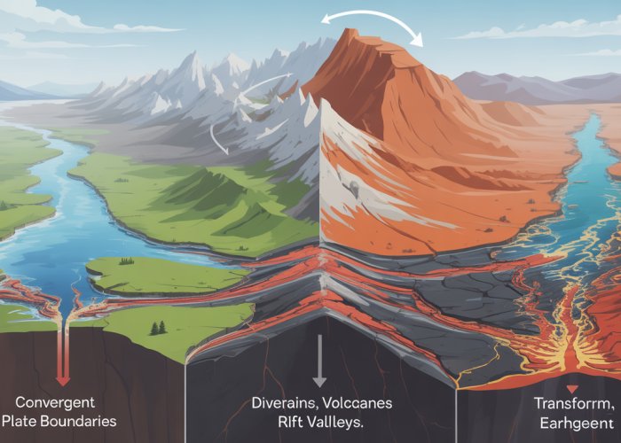
The main types are convergent (plates collide), divergent (plates move apart), and transform (plates slide past each other). Each type of interaction leads to different geological features and events.
How do tectonic plates interactions cause earthquakes?
Earthquakes primarily occur at plate boundaries, especially along convergent and transform boundaries. The immense pressure buildup from the friction of the tectonic plates interactions eventually overcomes the resistance, resulting in a sudden release of energy in the form of seismic waves.
What geological features are formed at convergent plate boundaries?
Convergent boundaries, where tectonic plates interactions involve collisions, can form mountain ranges, volcanoes, and deep-sea trenches. The Himalayas are a prime example of a mountain range formed by the collision of the Indian and Eurasian plates.
Can tectonic plates interactions affect climate?
Yes, indirectly. Volcanic eruptions, often associated with tectonic plate interactions, release gases and particles into the atmosphere that can influence global temperatures. Over very long timescales, the rearrangement of continents due to plate tectonics can also alter ocean currents and weather patterns.
So, there you have it! A little peek behind the curtain of our ever-shifting planet. Hopefully, you’ve gained some new appreciation for how tectonic plates interactions shape the world beneath our feet. Keep looking up (and down!) and stay curious!